|
He drove out of the Carson City Motel 6 leaving behind the single family mothers and 20 something males in the rain. He feared it might rain all day. | Instead of rain he drove through a blizzard on Highway 50 as it wound its way over the mountains in Nevada's Toiyabe National Forest. He made it to Ely, another little Nevada town with a couple of gambling casinos in between gas stations and what is left of the town from the 1950's. He did eat excellent Chinese food before crawling into bed. |
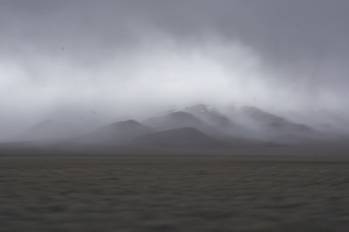
| The next morning He headed north towards Utah to look for Nancy Holt's Sun Tunnels. However at the turnoff from Highway 80 a digital electronic message sign spelled out the warning "road closed due to flooding". Stymied by the inundating waters he headed east over the Bonneville Salt Flats towards Salt Lake City. | Robert Smithson's Spiral Jetty was somewhere north of Salt Lake City. After getting gas he followed the highway north until it split, the road west veering towards the Great Salt Lake. The closest landmark to Spiral Jetty is the Golden Spike National Historic Site. He found Spiral Jetty five hours later at the end of one dirt road which branched off another dirt road. Much of the rock form which makes up the jetty has been silted over. There were approximately 20 people wandering over the jetty or taking pictures on a weekday in the spring. | |
|
| He spent the night in Brigham City, Utah. The next morning he got the oil changed and walked over to the laundromat and watched his clothes spin in the automated dryer. Bear River Migratory Bird Refuge is in between the Great Salt Lake and Brigham City. | Besides birds the Refuge was divided by myriad canal like tributaries flanked by fishermen, rods in water. He watched some young men catch an enormous catfish in one of the riverlets. After that he drove to Provo, Utah, a college town, and ate Vietnamese food prepared and served by Vietnamese before sleeping in a Ramada Inn. The following morning he headed towards Capitol Reef which is located in south-central Utah in 'red rock' country. |
|
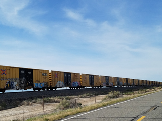
Yellow boxcars graffiti covered strung out on a spur off the main line near Black Rock Utah. | Capitol Reef National Park is one of a number of national parks in southern Utah. It is filled with cliffs, canyons, domes and natural bridges in what is called the Waterpocket Fold, a geologic monocline (a wrinkle on the earth). |
|
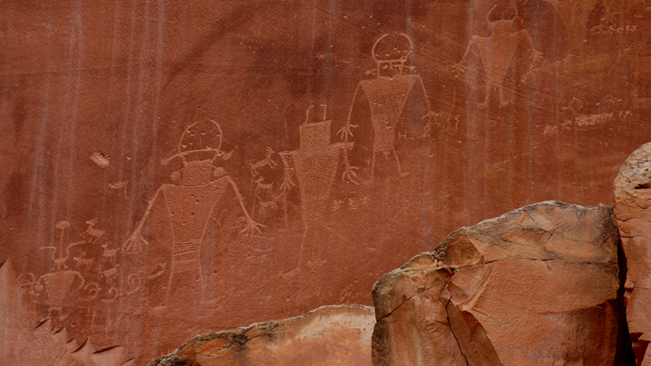
Tucked away at the bottom of a shear cliff off Highway 24 were the Native American Petroglyphs which resemble spacemen with bubble helmets. These 'spacemen' were probably spirit travelers or dancers. Rock art figures created by ancient Native Americans can be seen in several places in Capitol Reef National Park. Most are attributed to the Fremont Culture, which flourished in areas of Utah from approximately AD 600 to 1300. | The Fremont people were contemporaries of the Ancestral Anasazi of the Four Corners area. He had not realized that there were petroglyphs in this park. The 'spacemen' were a favorite from books of native american petroglyphs. The petroglyphs were carved into the red rock. Adjacent to one group of glyphs were some 20th century scatchings, initials presumably of someone who loved someone who had visited the canyon. Several miles down the road from the petroglyphs was a dried up river bed which had carved through the rocks to create a steep narrow canyon. Floods from seasonal rains still flow down this canyon. |
|
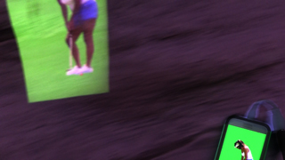
He owned a very small micro projector called a miniRay which connects directly to an android phone and plays whatever video is playing on the phone. | golferPutting is an animation of a young woman putting which was recorded at the Riis Park golf course in Queens, New York. This putter projection is an electronic 'glyph'. A signature on the face of the red rock which disappears when the power is turned off. |